File:Temporal data.jpg
From Nordan Symposia
Jump to navigationJump to search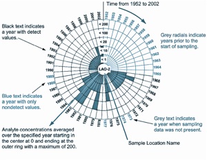
No higher resolution available.
Temporal_data.jpg (300 × 232 pixels, file size: 34 KB, MIME type: image/jpeg)
http://www.esri.com/news/arcuser/1104/temporal.html
This map, entitled "A New Method to Represent Temporal Data Sets," is one of many outstanding maps that were included in ESRI Map Book, Volume 19, GIS—The Language of Geography. For more information about this map, contact Thomas Riggs of the Los Alamos National Laboratory at tlriggs@lanl.gov.
File history
Click on a date/time to view the file as it appeared at that time.
| Date/Time | Thumbnail | Dimensions | User | Comment | |
|---|---|---|---|---|---|
| current | 00:57, 8 December 2008 | | 300 × 232 (34 KB) | Rdavis (talk | contribs) | http://www.esri.com/news/arcuser/1104/temporal.html This map, entitled "A New Method to Represent Temporal Data Sets," is one of many outstanding maps that were included in [http://www.esri.com/mapmuseum/mapbook_gallery/volume19/index.html ESRI Map Book, |
You cannot overwrite this file.
File usage
There are no pages that use this file.