File:Fars Province.jpg
Fars_Province.jpg (250 × 168 pixels, file size: 25 KB, MIME type: image/jpeg)
http://www.boston.com/bigpicture/2009/01/earth_observed.html
This simulated natural-color image of southeastern Fars province in southern Iran shows a dry river channel carving through arid mountains toward the northeast. A broad belt of lush agricultural land follows the curve of the alluvial fan and stretches out along a road that runs parallel to the ridgeline. The valley-ward margin of the intensely green agricultural belt fades to dull green along streams (or irrigation canals). The image was captured by the Advanced Spaceborne Thermal Emission and Reflection Radiometer (ASTER) on NASA's Terra satellite on October 12, 2004. (NASA/Jesse Allen, NASA/GSFC/METI/ERSDAC/JAROS, U.S./Japan ASTER Science Team) #
File history
Click on a date/time to view the file as it appeared at that time.
| Date/Time | Thumbnail | Dimensions | User | Comment | |
|---|---|---|---|---|---|
| current | 20:45, 15 January 2009 | 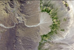 | 250 × 168 (25 KB) | Rdavis (talk | contribs) | http://www.boston.com/bigpicture/2009/01/earth_observed.html This simulated natural-color image of southeastern Fars province in southern Iran shows a dry river channel carving through arid mountains toward the northeast. A broad belt of lush agricultura |
You cannot overwrite this file.
File usage
There are no pages that use this file.