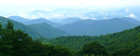
Blue Ridge Mountains
The Blue Ridge, or Blue Ridge Mountains, is a physiographic province of the larger Appalachian division. The province consists of the Northern and Southern physiographic sections, which divide near the Roanoke River gap.[1] They are a mountain chain in the eastern United States, part of the Appalachian Mountains, forming their eastern front from Georgia to Pennsylvania. To the west of the Blue Ridge, between it and the bulk of the Appalachians, lies the Great Valley, bordered on the west by the Ridge and Valley province. The mountains are well known for their bluish color when seen from a distance. Trees put the "blue" in Blue Ridge, from the hydrocarbons released into the atmosphere, thereby contributing to the characteristic haze on the mountains and their distinctive color.[2]
Within the Blue Ridge province, there are two two national parks: the Shenandoah in the northern section and the Great Smoky Mountains in the southern section. The Blue Ridge also contains the Blue Ridge Parkway, a 469-mile long scenic highway that connects the two parks and is located along the ridge crestlines along the Appalachian Trail.[3]
Geography
- See also: List of Mountains of the Blue Ridge
Although the term "Blue Ridge" is sometimes applied exclusively to the eastern edge or front range of the Appalachian Mountains, the geological definition of the Blue Ridge province extends westward to the Ridge and Valley area, encompassing the Great Smoky Mountains, the Great Balsams, the Roans, the Brushy Mountains (a "spur" of the Blue Ridge) and other mountain ranges.
The Blue Ridge extends north into Pennsylvania as South Mountain. While South Mountain dwindles to mere hills between Gettysburg and Harrisburg, the band of ancient rocks that forms the core of the Blue Ridge continues northeast through the New Jersey and Hudson River highlands, eventually reaching The Berkshires of Massachusetts and the Green Mountains of Vermont.
The Blue Ridge contains the highest mountains in eastern North America. About 125 peaks exceed 5,000 feet in elevation.[4] The highest peak in the Blue Ridge and the Appalachian chain is Mt. Mitchell in North Carolina at Template:Convert. There are 39 peaks in North Carolina and Tennessee higher than Template:Convert; by comparison, only New Hampshire's Mt. Washington rises above 6,000 feet in the northern portion of the Appalachian chain.
The Blue Ridge Parkway runs 469 miles (750 km) along the crests of the Southern Appalachians and links two national parks: Shenandoah and Great Smoky Mountains. In many places along the parkway, there are metamorphic rocks (gneiss) with folded bands of light-and dark-colored minerals, which sometimes look like the folds and swirls in a marble cake.
Geology
Most of the rocks that form the Blue Ridge Mountains are ancient granitic charnockites, metamorphosed volcanic formations, and sedimentary limestones.Recent studies completed by Richard Tollo, a professor and geologist at the George Washington University, provide greater insight into the petrologic and geochronologic history of the Blue Ridge basement suites. Modern studies have found that the basement geology of the Blue Ridge is made of compositionally unique gneisses and granitoids, including orthopyroxene-bearing charnockites. Analyses of zircon minerals in the granites completed by John Aleinikoff at the U.S. Geological Survey have provided more detailed emplacement ages.
Many of the features found in the Blue Ridge and documented by Tollo and others have confirmed that the rocks exhibit many similar features in other North American Grenville-age terranes. The lack of a calc-alkaline affinity and zircon ages less than 1,200 Ma suggest that Blue Ridge are unique from the Adirondacks, Green Mountains, and possibly the New York-New Jersey Highlands. The petrologic and geochronologic data suggest that the Blue Ridge basement is a composite orogenic crust that was emplaced during several episodes from a crustal magma source. Field relationships further illustrate that rocks emplaced prior to 1,078-1,064 Ma preserve deformational features. Those emplaced post-1,064 Ma generally have a massive texture and missed the main episode of Mesoproterozoic compression.[5]
History
The English who settled Virginia in the early 1600s recorded that the native Powhatan name for the Blue Ridge was Quirank.
At the foot of the Blue Ridge, various tribes including the Siouan Manahoacs, the Iroquois, and the Shawnee hunted and fished. As more settlers moved into Virginia, their economic and at times martial competition pushed the native inhabitants west.[6]
Flora and fauna
Popular culture
- The song "Honeysuckle Blue" by Drivin N Cryin
- The song "Stonewall Jackson's Way"[7]
- The chorus of the popular song, The Trail of the Lonesome Pine. The song was popularized in the 1930s by the comedy duo Laurel and Hardy, who sang it in their film, Way Out West. Their recording was released (posthumously) in 1975, achieving chart success in the United Kingdom.[8]
- John Denver sang of the Blue Ridge in the celebrated 1971 song "Take Me Home, Country Roads". The lyrics place the mountain range in the state of West Virginia, although in fact, the only part of the range falling within that state is at its easternmost tip, at a point near Harper's Ferry.
See also
References
Template:Reflist 9. Ted Olson (1998), _Blue Ridge Folklife_, University Press of Mississippi (Folklife in the South Series). ISBN 1578060230.
External links

Template:Geography navigation Template:Physical Geography Sub-disciplines Template:Pennsylvania Template:Maryland Template:West Virginia Template:Virginia Template:Tennessee Template:North Carolina Template:South Carolina Template:Georgia